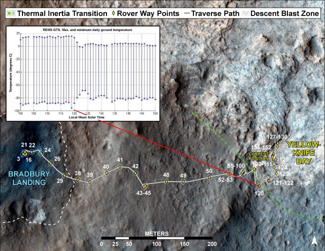
Curiosity's Traverse into Different Terrain,  This image maps the traverse of NASA's Mars rover Curiosity from "Bradbury Landing" to "Yellowknife Bay," with an inset documenting a change in the ground's...

Curiosity's Traverse into Different Terrain


This image maps the traverse of NASA's Mars rover Curiosity from "Bradbury Landing" to "Yellowknife Bay," with an inset documenting a change in the ground's thermal properties with arrival at a different type of terrain. Between Sol (Martian day) 120 and Sol 121 of the mission on Mars (Dec. 7 and Dec. 8, 2012), Curiosity crossed over a terrain boundary into lighter-toned rocks that correspond to high thermal inertia values observed by NASA's Mars Odyssey orbiter. The green dashed line marks the boundary between the terrain types. The inset graphs the range in ground temperature recorded each day by the Rover Environmental Monitoring Station (REMS) on Curiosity. Note that the arrival onto the lighter-toned terrain corresponds with an abrupt shift in the range of daily ground temperatures to a consistently smaller spread in values. This independently signals the same transition seen from orbit, and marks the arrival at well-exposed, stratified bedrock. Sol 120 (Dec. 7, 2012) marks the arrival at the Shaler Unit where scientists saw cross-bedding that is evidence of water flows. Sol 125 (Dec. 12, 2012) marks the arrival into an area called "Yellowknife Bay," where sulfate-filled veins and concretions were discovered in the Sheepbed Unit, along with much finer-grained sediments. The thin dashed line is based on Odyssey thermal inertia mapping in 2005 by Robin Fergason and co-authors. The mapped area is within Gale Crater and north of the mountain called Mount Sharp in the middle of the crater. After the first use of the drill, the rover's main science destination will be on the lower reaches of Mount Sharp. For broader-context images of the area, see PIA16064 and PIA16058 .The base image from the map is from the High Resolution Imaging Science Experiment Camera (HiRISE) in NASA's Mars Reconnaissance Orbiter.

Image credits: NASA/JPL-Caltech/Univ. of Arizona/CAB(CSIC-INTA)/FMI
Image released by NASA on 2013-01-15 as catalog id PIA16708
This photo was taken 11 years ago and uploaded to photonado 11 years ago
12 views.

Photostream

photo: photo: photo: photo: photo:

Tags

License

cc-by-nc Attribution-NonCommercial

Privacy

This photo is visible for everyone

Flag this photo

Flag this photo

Metadata

Original size:  3300x2550
Full metadata.

Share this photo

Link to this photo
Embed this photo