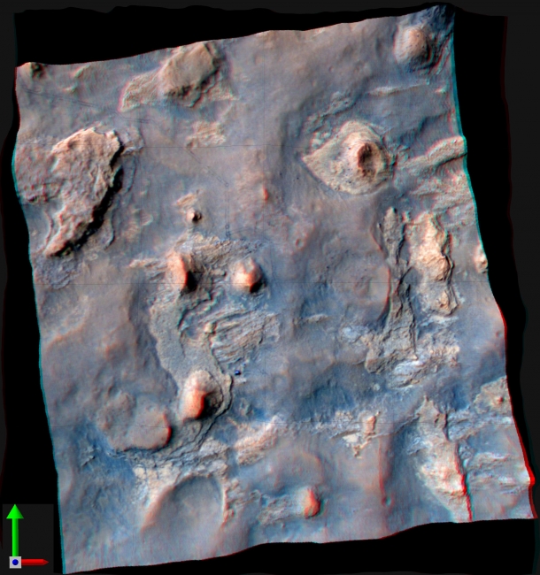
Stereo View of Curiosity and Rover Tracks at 'the Kimberley,' April 2014, NASA's Curiosity Mars rover and tracks from its driving are visible in this view combining information from three observations by the High Resolution Imaging...

Stereo View of Curiosity and Rover Tracks at 'the Kimberley,' April 2014


NASA's Curiosity Mars rover and tracks from its driving are visible in this view combining information from three observations by the High Resolution Imaging Science Experiment (HiRISE) camera on NASA's Mars Reconnaissance Orbiter. The image appears three-dimensional when viewed through red-blue glasses with the red lens on the left. An image taken by HiRISE on April 11, 2014, when Curiosity was near the butte in the lower-left quadrant of the image, has been combined with three-dimensional information about the terrain from a pair of earlier HiRISE images. The vertical dimension is exaggerated compared to horizontal dimensions. The butte in the lower left quadrant is informally called "Mount Remarkable." The rover, appearing bright blue in the enhanced color of this image, is at the two-o'clock position in relation to the Butte. Curiosity entered the area included in this image on March 12, 2014, along the tracks visible near the upper left corner. The distance between parallel wheel tracks is about 9 feet (2.7 meters). The area included in the image is about 1,200 feet (about 365 meters) wide. The April 11 HiRISE image without the added topographical information is online at PIA18081 . A rover's-eye view including Mount Remarkable, taken by Curiosity on the same day, is online at PIA18083 .The location taking up most of the left half of this image is called "the Kimberley." About a year before Curiosity arrived here, the rover's science team chose this location for investigating because it contains a set of outcrops of different types of rock layers exposed close together. The site is along the route of the mission's journey from the Yellowknife Bay area, where Curiosity found evidence of an ancient lakebed environment favorable for microbial life, to long-term destinations on the lower slopes of Mount Sharp. HiRISE is one of six instruments on NASA's Mars Reconnaissance Orbiter. The University of Arizona, Tucson, operates HiRISE, which was built by Ball Aerospace & Technologies Corp., Boulder, Colo. NASA's Jet Propulsion Laboratory, a division of the California Institute of Technology in Pasadena, manages the Mars Reconnaissance Orbiter and Mars Science Laboratory projects for NASA's Science Mission Directorate, Washington. For more information about Curiosity, visit http://www.nasa.gov/msl and http://mars.jpl.nasa.gov/msl/ .

Image credits: NASA/JPL-Caltech/Univ. of Arizona
Image released by NASA on 2014-04-16 as catalog id PIA18082
This photo was taken 10 years ago and uploaded to photonado 9 years ago
41 views.

Photostream

photo: photo: photo: photo: photo:

Tags

License

cc-by-nc Attribution-NonCommercial

Privacy

This photo is visible for everyone

Flag this photo

Flag this photo

Metadata

Original size:  3287x3497
Full metadata.

Share this photo

Link to this photo
Embed this photo