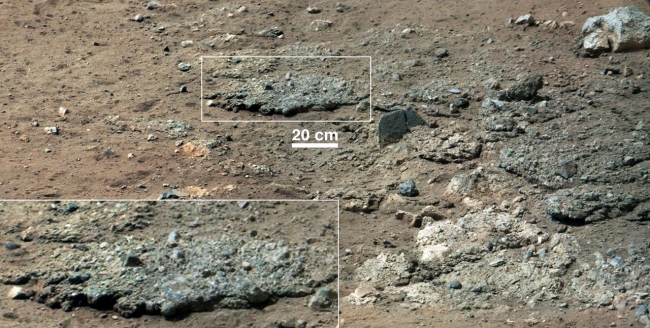
Best View of Goulburn Scour, This image from NASA's Curiosity Rover shows a high-resolution view of an area that is known as Goulburn Scour, a set of rocks blasted by the engines of Curi...

Best View of Goulburn Scour


This image from NASA's Curiosity Rover shows a high-resolution view of an area that is known as Goulburn Scour, a set of rocks blasted by the engines of Curiosity's descent stage on Mars. It shows a section from a mosaic of a pair of images obtained by Curiosity's 100-millimeter Mast Camera, with three times higher resolution than previously released. Details of the layer of pebbles can be seen in the close-up. These two images were the first views of this sandy conglomerate, a sedimentary layer laid down by water in the very distant past and uncovered in August 2012 during the rover's landing. The inset magnifies the area by a factor of two. Mastcam obtained these images on Aug. 19, 2012, or the 13th sol, or Martian day, of Curiosity's surface operations. JPL manages the Mars Science Laboratory/Curiosity for NASA's Science Mission Directorate in Washington. The rover was designed, developed and assembled at JPL, a division of the California Institute of Technology in Pasadena. For more about NASA's Curiosity mission, visit: http://www.jpl.nasa.gov/msl , http://www.nasa.gov/mars , and http://marsprogram.jpl.nasa.gov/msl .

Image credits: NASA/JPL-Caltech/MSSS
Image released by NASA on 2012-09-27 as catalog id PIA16187
This photo was taken 12 years ago and uploaded to photonado 11 years ago
7 views.

Photostream

photo: photo: photo: photo: photo:

Tags

License

cc-by-nc Attribution-NonCommercial

Privacy

This photo is visible for everyone

Flag this photo

Flag this photo

Metadata

Original size:  1280x646
Full metadata.

Share this photo

Link to this photo
Embed this photo