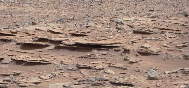
Layered Martian Outcrop 'Shaler' in 'Glenelg' Area, Figure 1 Figure 2 Click on an individual image for larger views The NASA Mars rover Curiosity used its Mast Camera (Mastcam) during the mission's 120th Marti...

Layered Martian Outcrop 'Shaler' in 'Glenelg' Area


Figure 1 Figure 2 Click on an individual image for larger views The NASA Mars rover Curiosity used its Mast Camera (Mastcam) during the mission's 120th Martian day, or sol (Dec. 7, 2012), to record this view of a rock outcrop informally named "Shaler." The outcrop's striking layers, some at angles to each other in a pattern called crossbedding, made it a target of interest for the mission's science team. The site is near where three types of terrain meet at a place called "Glenelg," inside Gale Crater. The area covered by the image spans about 3 feet (90 centimeters) in the foreground. Figure 1 includes a 10-centimeter (4-inch) scale bar. The image has been white-balanced to show what the rock would look like if it were on Earth. Figure 2 is a raw-color version, showing what the rock looks like on Mars to the camera. Malin Space Science Systems, San Diego, developed, built and operates Mastcam. JPL, a division of the California Institute of Technology, Pasadena, manages the Mars Science Laboratory Project for NASA's Science Mission Directorate, Washington. JPL designed and built the project's Curiosity rover. For more about NASA's Curiosity mission, visit: http://www.jpl.nasa.gov/msl , http://www.nasa.gov/mars , and http://mars.jpl.nasa.gov/msl .

Image credits: NASA/JPL-Caltech/MSSS
Image released by NASA on 2012-12-11 as catalog id PIA16550
This photo was taken 11 years ago and uploaded to photonado 11 years ago
15 views.

Photostream

photo: photo: photo: photo: photo:

Tags

License

cc-by-nc Attribution-NonCommercial

Privacy

This photo is visible for everyone

Flag this photo

Flag this photo

Metadata

Original size:  2438x1141
Full metadata.

Share this photo

Link to this photo
Embed this photo