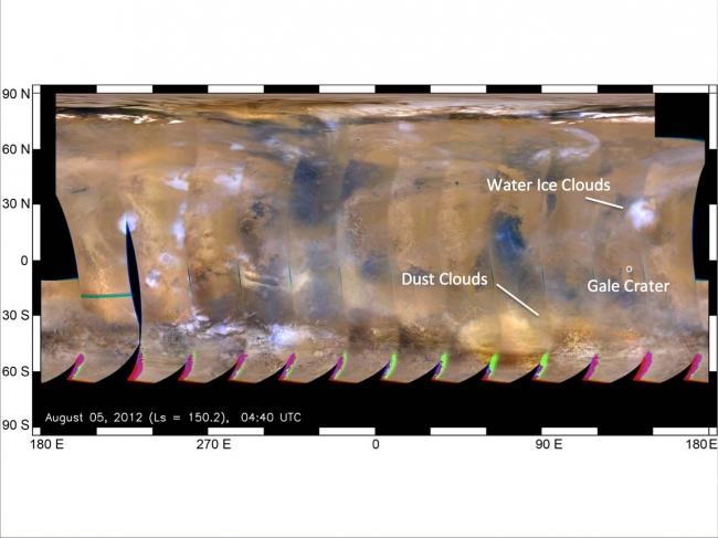
Mars Weather Map, Aug. 5, This global map of Mars was acquired on Aug. 5, 2012, by the Mars Color Imager instrument on NASA's Mars Reconnaissance Orbiter. One global map is generated ...

Mars Weather Map, Aug. 5


This global map of Mars was acquired on Aug. 5, 2012, by the Mars Color Imager instrument on NASA's Mars Reconnaissance Orbiter. One global map is generated each day to forecast weather conditions for the entry, descent and landing of NASA's Curiosity rover. The atmosphere is clear and seasonal around Gale Crater, in agreement with the computer models used to simulate Curiosity's landing. The dust storm southwest of Gale Crater, first seen on July 31, changed into an inactive dust cloud on Aug. 2, and now has dispersed even further. Dust activity had been picking up on parts of the planet before landing, but none of these dust clouds arrived at Gale Crater before Curiosity did. JPL manages the Mars Science Laboratory/Curiosity for NASA's Science Mission Directorate in Washington. The rover was designed, developed and assembled at JPL, a division of the California Institute of Technology in Pasadena. For more about NASA's Curiosity mission, visit: http://www.jpl.nasa.gov/msl , http://www.nasa.gov/mars , and http://marsprogram.jpl.nasa.gov/msl .

Image credits: NASA/JPL-Caltech/MSSS
Image released by NASA on 2012-08-10 as catalog id PIA16037
This photo was taken 12 years ago and uploaded to photonado 11 years ago
55 views.

Photostream

photo: photo: photo: photo: photo:

Tags

License

cc-by-nc Attribution-NonCommercial

Privacy

This photo is visible for everyone

Flag this photo

Flag this photo

Metadata

Original size:  1449x1087
Full metadata.

Share this photo

Link to this photo
Embed this photo